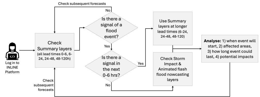
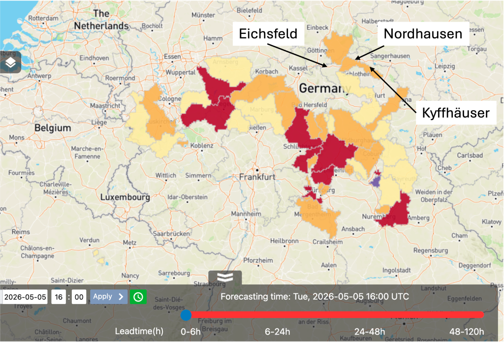
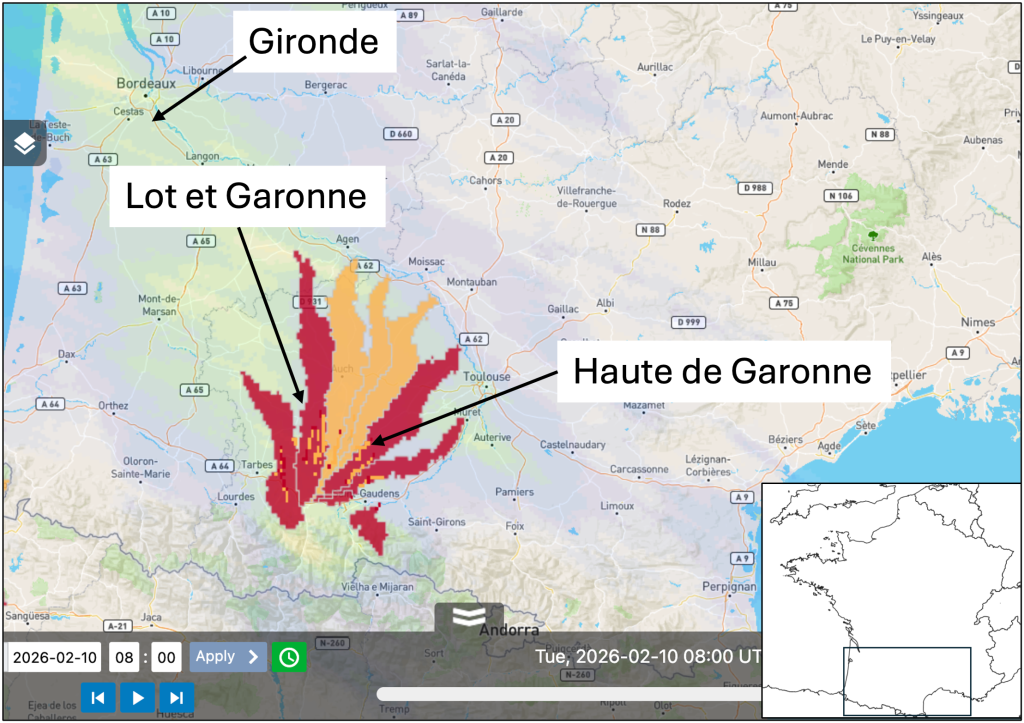
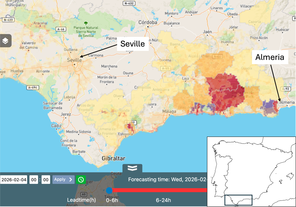
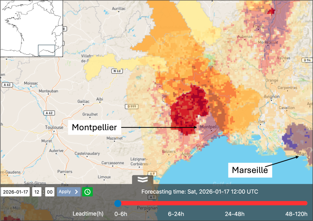
When analysing each of the above events, we advise loading the forecast layers 24-hours before the event start date and checking the summary layers. Next, load the forecast 6-hours later and repeat the process. Then, load the forecast 3-hours ahead of the event start date, now you can also view the layers in the Storm Impact and Animated flash flood nowcasting groups. This workflow is summarised below (Figure 1).
Figure 1: Suggested workflow for using the layers in the INLINE web platform to analyse if an event is forecasted in your area of interest.
Southern Spain - 29th October 2025
Event description
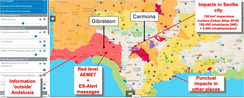
Heavy rainfall on the 29th October 2025 brought flash flooding in Andalucia in southern Spain. The heavy rain started in the west of the affected area, close to the border with Portugal at 08:00 UTC, it moved westwards and ended at approximately 20:00 UTC on the 29th October 2025. In the province of Seville, one person was injured in the town of Carmona. In Huelva province, one person was injured in the town of Gibraleon. Roads were also cut off across the provinces of Seville, Huelva and Malaga.
Areas in Andalucia affected by flash flooding during 29th October 2025. Image and information provided by EMA.
Analysing the INLINE Forecasts
24-hours ahead of the event – 28th October 2025 08:00 UTC
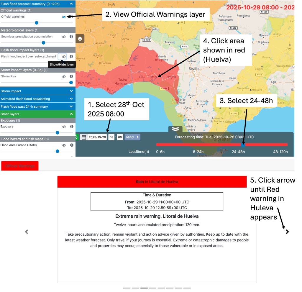
Firstly load the forecast for the 28th October 2025 at 08:00 UTC using the date and time selector at the bottom of the web platform and navigate to southern Spain close to the city of Seville. Then follow the instructions given below in Figure 1.
The Official Warnings layer shows Huelva with a red warning for rain between 11:00 – 12:59 UTC on the 29th October 2025. This information can be used to identify the start and duration of the event and the affected areas.
Figure 1: Instructions on viewing the Official warnings layer for the 28th October 2025 08:00 UTC forecast.
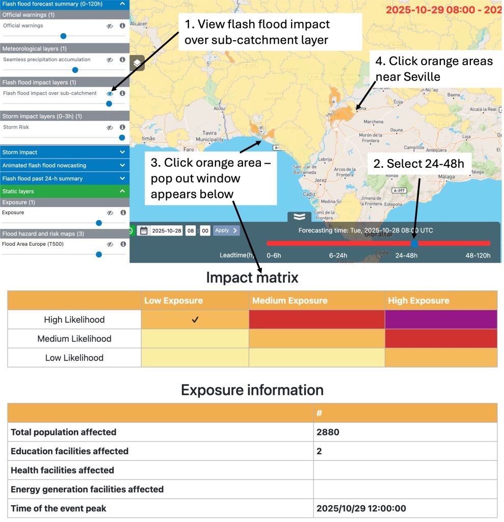
Next, from the same Flash flood forecast summary group of layers, visualise the Flash flood impact over sub-catchment layer, again select 24-48h from the red time slider, follow the instructions in Figure 2.
This layer highlights sub-catchments in Huelva and Seville where there is a risk of Medium flash flood impacts (shown as orange). Clicking on the sub-catchments brings up a pop out window, the expected peak is 12:00 UTC on the 29th October in Huelva and 18:00 UTC on the 29th October in Seville.
Figure 2: Instructions on viewing the Flash flood impact over sub-catchment layer for the 28th October 2025 08:00 UTC forecast.
You can analyse these forecast layers for each subsequent hour, for this walkthrough we will jump to the forecast at 06:00 UTC on the 29th October 2025, which is 2-hours ahead of the event onset.
2-hours ahead of the event – 29th October 2025 06:00 UTC
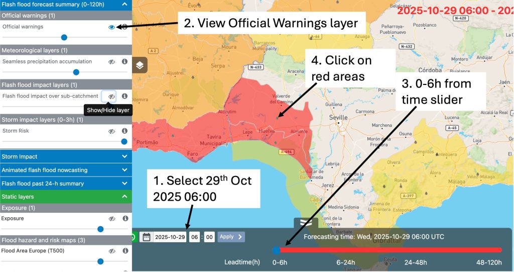
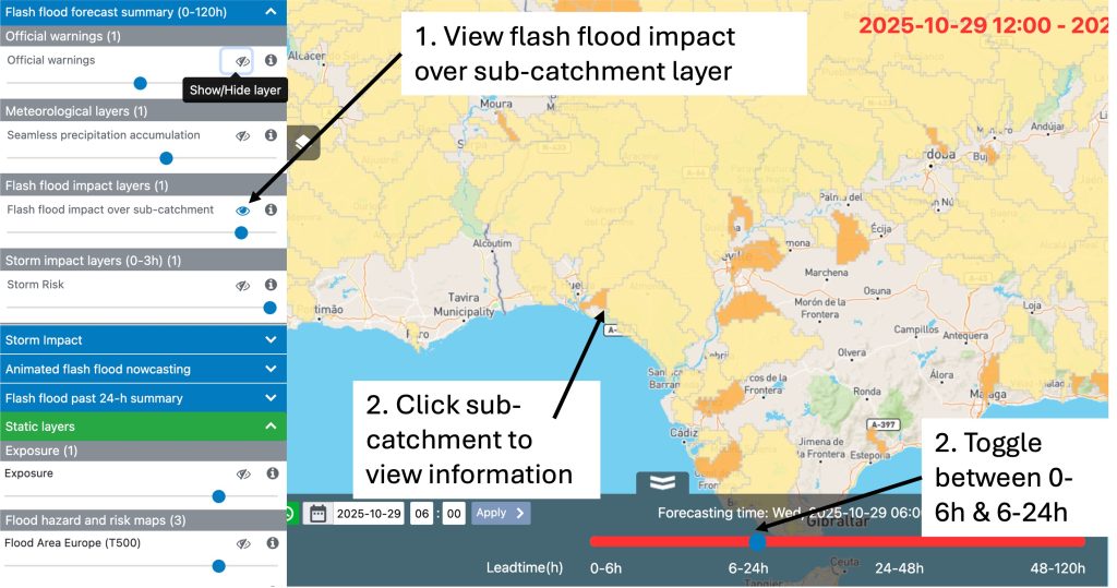
2-hours ahead of the event onset at 06:00 UTC on the 29th October 2025, the Official warnings layer is showing red warning areas close to Huelva for 0-6 and 6-24 hours (see Figure 3). The river flash flood impact over sub-catchment layer shows little signal for 0-6 hours, but shows a greater signal at 6-24 hours, with orange sub-catchments highlighted near Seville (Figure 4), the information in the pop out window suggests the peak is expected at 18:00 UTC.
Figure 3: Instructions on viewing the Official warnings layer for the 29th October 2025 06:00 UTC forecast.
Figure 4: Instructions on viewing the Flash flood impact over sub-catchment layer for the 29th October 2025 06:00 UTC forecast.
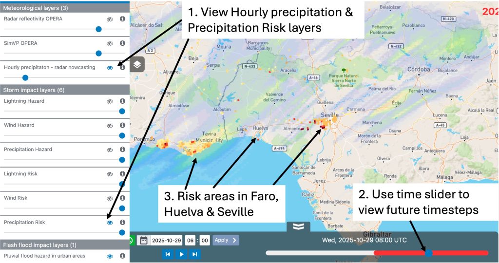
The lack of signal in the River flash flood impact over sub-catchment layer could be because the flash flooding is related to pluvial rather than riverine processes. Therefore, we will analyse the layers within the Storm Impact grouping, which focus upon pluvial flash flooding. Within this grouping the Precipitation Risk layer shows a strong signal, particularly at 08:00 UTC, as shown in Figure 5 below.
Figure 5: Instructions on viewing the Precipitation risk layer for the 29th October 2025 06:00 UTC forecast.
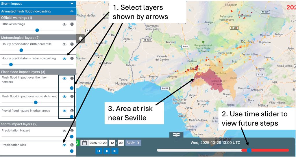
The layers selected above show flash flood risk around Seville from 13:00 UTC, which extends up to 18:00 UTC. This risk is shown by the presence of shaded grid cells and river sub-catchments around Seville.
Figure 7. Instructions on viewing the Animated flash flood nowcasting layers for the 29th October 2025 12:00 UTC forecast.
North Thuringia, Germany - 5th May 2026
Event start: 5th May 2026 at 16:00 UTC.
Description: Heavy rainfall, moving from south to north across northern Thuringia in central Germany on the 5th May 2026 resulted in flash flooding. The districts of Nordhausen, Eichsfeld and Kyffhauser particularly affected, where flooded basements and streets were reported.
Storm Nils, Southern France - 10th February 2026
Event start: 10th February 2026 at 08:00 UTC.
Description: Storm Nils firstly made landfall along the Atlantic coast in south-west France, near Gironde on the 10th February, then moved south-east towards Toulouse. Heavy rainfall on the 10th and into the 11th February caused rivers like the Garonne to rise rapidly. Wind gusts from the storm left 850,000 to 900,000 households without power initially, with 450,000 still without electricity the following day. Approximately 1,600 people were evacuated across Gironde and Lot-et-Garonne.
Storm Leonardo, Andalucia, Southern Spain - 4th February 2026
Event start: 4th February 2026 at 00:00 UTC.
Description: Storm Leonardo was one of a procession of storms which affected the Iberian peninsula during the winter of 2026. Flood impacts were reported across the peninsula but this example focuses on the area in Andalucia around Seville to Almeria. Heavy rain began to fall in this area from 00:00 UTC on the 4th February and continued throughout the day, resulting in urban and river flash flooding.
Southern France - 17th January 2026
Event start: 17th January 2026 at 12:00 UTC.
Description: Heavy rain moving from south-east to north-west affected Montpellier from 09:00 UTC on the 17th January 2026, but flash flood impacts did not begin until 12:00 UTC. Heavy rainfall continued to affect the area into the 18th January 2026.
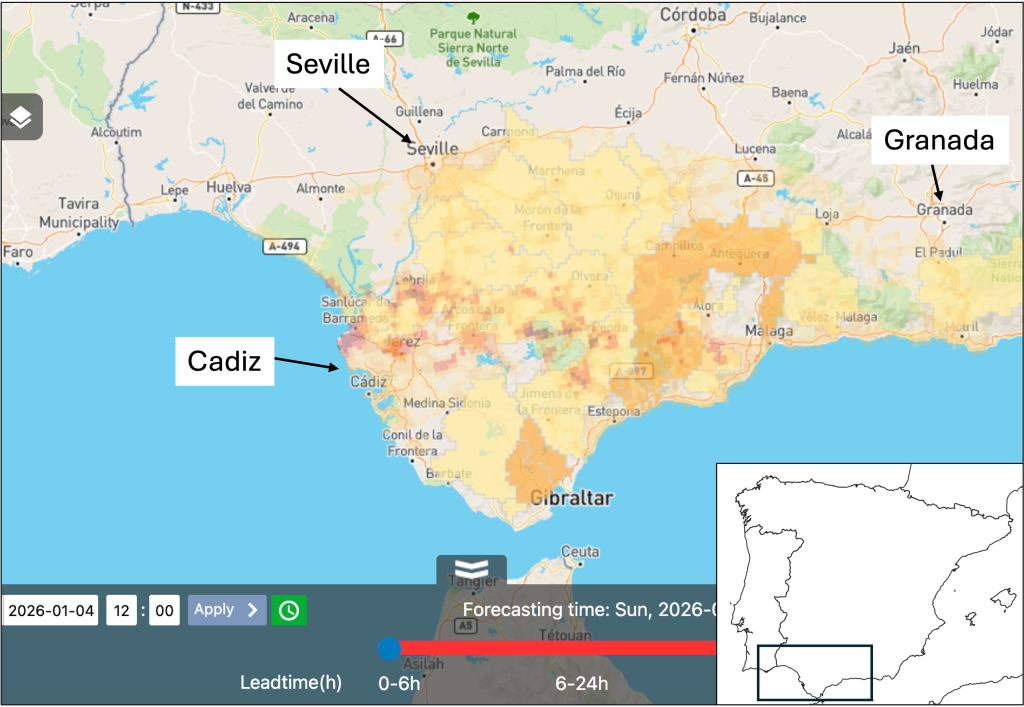
Storm Francis, Andalucía, Southern Spain - 4th January 2026
Event start: 4th January 2026 at 04:00 UTC.
Description: Storm Francis was one of the train of storms to affect the Iberian peninsula during the winter of 2026. This storm brought heavy rain and flooding across Andalucia from early in the morning of the 4th January from 04:00 UTC. The area between Seville, Cadiz and Granada was particularly affected by flash flooding.
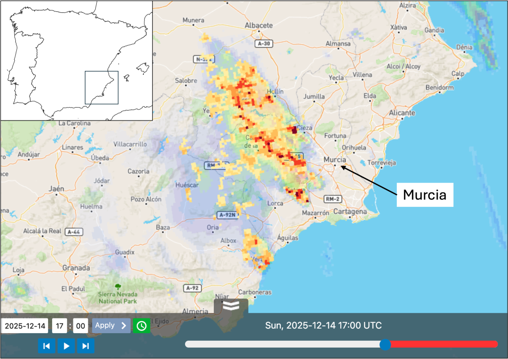
Murcia, Spain - 14th December 2025
Event start: 14th December 2025 at 17:00 UTC.
Description: Heavy rain moving from south-east to north-west had begun to fall to the south-west of Murcia from 11:00 UTC on the 14th December 2025. The rain system was very slow moving resulting in large localised rainfall totals. Heavy rainfall then began to move to the north-east of Murcia between 00:00-06:00 UTC on the 15th January, resulting in flooding in this area.
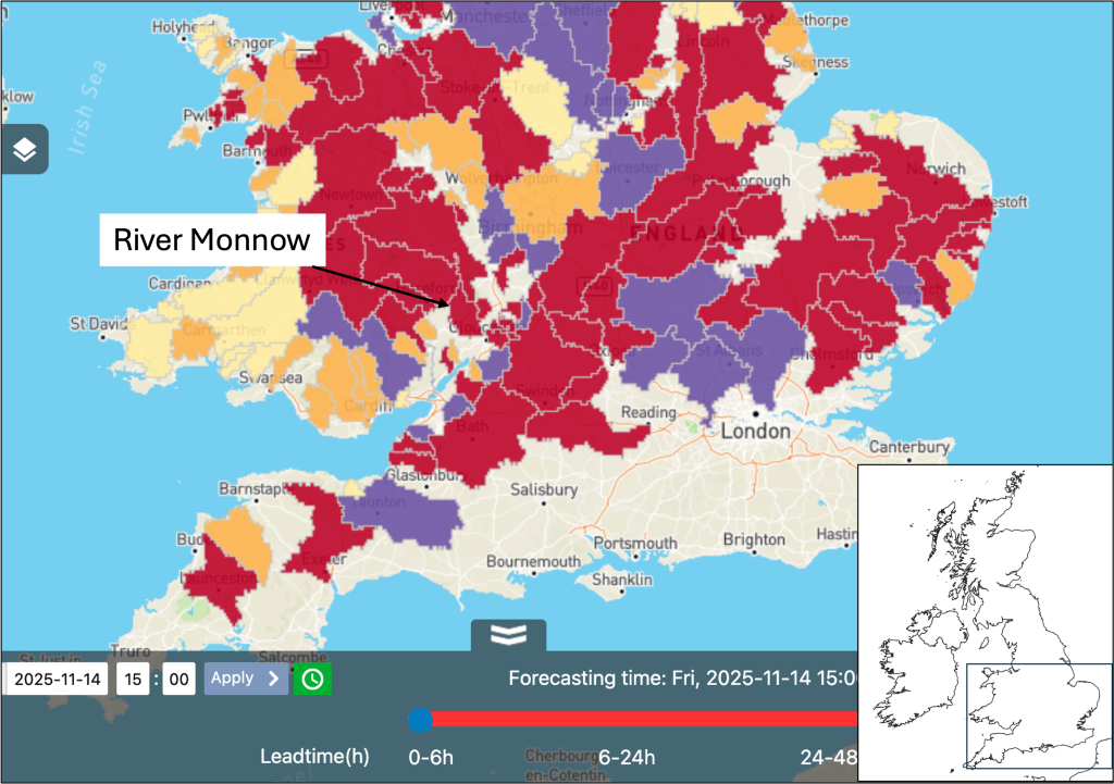
Storm Claudia, United Kingdom - 14th November 2025
Event start: 14th November 2025 at 14:00 UTC.
Description: Extensive heavy rainfall associated with storm Claudia stretching across central England and Wales.
In England, the Environment Agency reported 57 properties flooded, with 18,000 properties protected by flood defences. More than 50 properties were reported flooded in the Monmouth area alone. The River Monnow reached record levels, surpassing those seen during Storm Dennis in 2020 and Storm Bert in 2024. Dozens of people were rescued or evacuated from their homes in Monmouth. The Environment Agency issued flood warnings and alerts to over 165,000 people over the weekend.
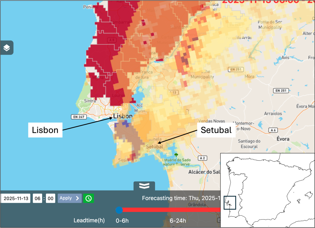
Setúbal, Portugal - 13th November 2025
Event start: 13th November 2025 at 03:00 UTC.
Description: Very heavy rainfall in the early hours of the morning affected Setúbal, to the south of Lisbon, Portugal. 2 fatalities were reported in Setubal where 43 incidents were also reported, 19 incidents reported in greater Lisbon.
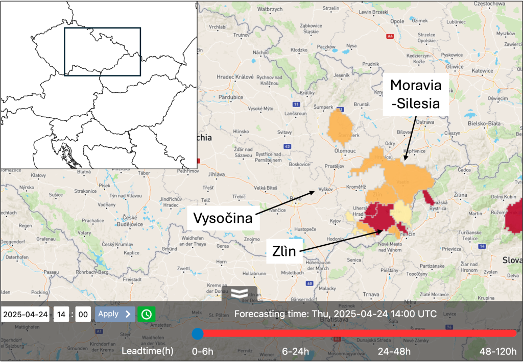
Czechia - 24th April 2025
Event start: 24th April 2025 at 14:00 UTC.
Description: Localised heavy rainfall affected the south-east of the country from the 24th April moving in an easterly direction into the early hours of the 25th April. Flash flooding was reported in the south-east of the country in Zlín, Moravia-Silesia and Vysočina regions.